
Reference works, Scholarly journals, Trade publications, and important General interest magazines covering core academic subject areas. Help Guide available.


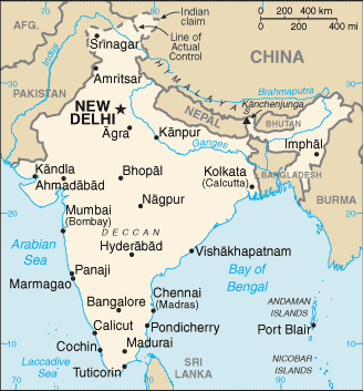
Border Countries: Bangladesh 4,142 km; Bhutan 659 km; Burma 1,468 km; China 2,659 km; Nepal 1,770 km; Pakistan 3,190 km
Terrain: Upland plain (Deccan Plateau) in south, flat to rolling plain along the Ganges, deserts in west, Himalayas in north
Elevation:
highest point: Kanchenjunga 8,586 m
lowest point: Indian Ocean 0 m
mean elevation: 160 m
Natural Resources: Coal (fourth-largest reserves in the world), antimony, iron ore, lead, manganese, mica, bauxite, rare earth elements, titanium ore, chromite, natural gas, diamonds, petroleum, limestone, arable land
Land Use:
Agricultural land: 60.5% (2018 est.)
arable land: 52.8% (2018 est.)
permanent crops: 4.2% (2018 est.)
permanent pasture: 3.5% (2018 est.)
forest: 23.1% (2018 est.)
other: 16.4% (2018 est.)
715,539 sq km (2020)
salt water lake(s): Chilika Lake - 1,170 sq km
Brahmaputra (shared with China [s] and Bangladesh [m]) - 3,969 km; Indus (shared with China [s] and Pakistan [m]) - 3,610 km; Ganges river source (shared with Bangladesh [m]) - 2,704 km; Godavari - 1,465 km; Sutlej (shared with China [s] and Pakistan [m]) - 1,372 km; Yamuna - 1,370 km; Narmada - 1,289 km; Chenab river source (shared with Pakistan [m]) - 1,086 km; Ghaghara river mouth (shared with China [s] and Nepal) - 1,080 km
note – [s] after country name indicates river source; [m] after country name indicates river mouth
Indian Ocean drainage: Brahmaputra (651,335 sq km), Ganges (1,016,124 sq km), Indus (1,081,718 sq km), Irrawaddy (413,710 sq km)
Indus-Ganges-Brahmaputra Basin
Learn About Indian Culture
A guide to traveling the world featuring information on embassies, business, societies, culture, food, education, and much more.
Information on the history, people, government, economy, geography, communications, transportation, military, etc. of entities across the world; government site maintained by the Central Intelligence Agency (CIA) of the United States

There are as many as 1,600 languages and dialects spoken in India. The official language in India is Hindi (in the Devanagari script). However, twenty-one other tongues are approved by the central government as co-official languages.
Based on the 2011 census, Hindi is the primary language for about 43 percent of Indian people, though it is spoken and understood by a much larger percentage of the population. Individual states are allowed to designate their own regional languages. The most prevalent of the official languages are Bengali, Telugu, Marathi, Tamil, Urdu, Gujarati, Malayalam, Kannada, Oriya, Punjabi, and Assamese.
English is also an important language in the country and, along with Hindi, is the official language of communication for the national government. It is also important in commercial correspondence. Though there have been efforts to decrease the use of English for official business, this has been unpopular in regions with small Hindi-speaking populations.

Median Age:
total: 28.7 years
male: 28 years
female: 29.5 years (2020 est.)
country comparison to the world: 141
Population Growth Rate:
0.7% (2023 est.)
country comparison to the world: 127
Birth Rate:
16.53 births/1,000 population (2023 est.)
country comparison to the world: 94
Death Rate:
9.65 deaths/1,000 population (2023 est.)
country comparison to the world: 40
Net Migration Rate:
0.12 migrant(s)/1,000 population (2023 est.)
country comparison to the world: 79
Population Distribution:
with the notable exception of the deserts in the northwest, including the Thar Desert, and the mountain fringe in the north, a very high population density exists throughout most of the country; the core of the population is in the north along the banks of the Ganges, with other river valleys and southern coastal areas also having large population concentrations
Urbanization:
urban population: 36.4% of total population (2023)
rate of urbanization: 2.33% annual rate of change (2020-25 est.)
total population growth rate v. urban population growth rate, 2000-2030
Major Urban Areas - Population:
32.941 million NEW DELHI (capital), 21.297 million Mumbai, 15.333 million Kolkata, 13.608 million Bangalore, 11.776 million Chennai, 10.801 million Hyderabad (2023)
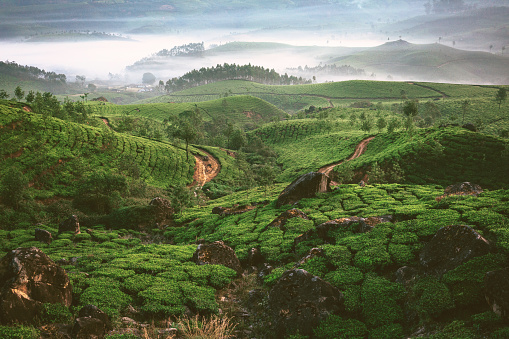
Landscape of India